
Know where your trucks are
and when they'll reach each stop.
The dispatch map shows the Samsara-linked trucks on your active routes, each route's stops and the freight still waiting for a truck. Open stops carry arrival estimates that start from the truck's Samsara position or the driver's phone in the RushHour driver app, or, without either, from the last completed stop or the plan, and each estimate says what it was based on. There is no tracking hardware to buy from us, and the map runs on Google Maps, OpenStreetMap or your own Radar, HERE or Mapbox account.
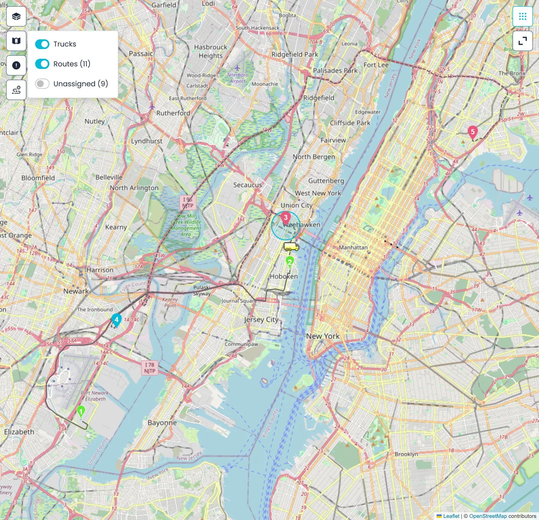
On the dispatch board
Trucks, stops and arrival times on the screen you dispatch from
The map sits on the dispatch board, by default between the route cards and the unassigned orders, so checking where a truck is, when it will arrive and which route should take the next pickup all happens in one place.
The map
A map that follows the route list
Select a route and its stops appear as numbered pickup and delivery pins in route order, joined by the route line: solid where a leg's stops are completed, dashed for the legs still to drive, with each leg's distance when you hover over it. Click a stop card and the map moves to that stop and draws a ring around it; click a pin and its stop card is selected in the route list. If a stop's address can't be placed on the map, a Stop not on map notice tells you so, instead of the map doing nothing.
- A Markers menu to show or hide trucks, routes and unassigned stops, with separate switches for the unassigned pickups and deliveries and counts beside all but trucks
- Unassigned pickups and deliveries on the same map as the routes
- Fullscreen map, and twelve board layouts that put the map where each dispatcher wants it
- Drawn on the map provider your company picked in Settings > Integrations
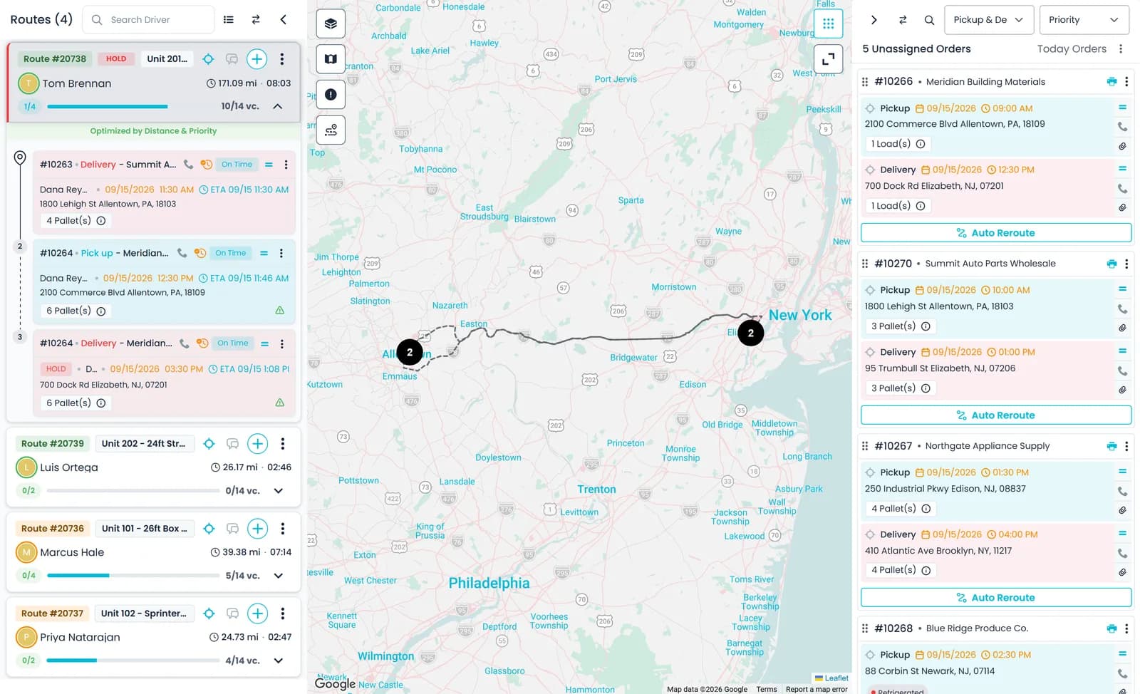
Truck positions
Where Samsara trucks are, and how far each driver is from a stop
RushHour does not sell tracking hardware; it uses what your trucks and drivers already carry. Connect your Samsara account in Settings > Integrations and link each truck to its Samsara vehicle, and the trucks on active routes appear on the dispatch map, with the driver's name, the plate and the truck name when you hover. Drivers who run the RushHour driver app share the phone's location while their route has stops left, and that position feeds the arrival estimates and driver distances on the board.
- Samsara-linked trucks on active routes shown on the map; select a route to see only its truck
- Positions refreshed about every two minutes while the board is open, and as soon as you return to the tab
- The focus button on a route card frames a Samsara-linked truck together with all of the route's stops
- Driver app positions feed arrival estimates and driver distances on the board and in the Assign Driver panel
- Live driver locations on the dispatch map from the driver appComing soon
- Settings > Fleet shows each linked truck's current Samsara location, vehicle name and VINNext release
Arrival estimates
Per-stop ETAs that say where they come from
Expand a route and each open stop can show an ETA chip. Every route uses the best position it has: the Samsara truck position first, then a driver app position no more than 20 minutes old. From that position, the next stop is estimated over the straight-line distance at a 50 mph planning speed, and each later stop adds the route's drive time for its leg. With no live position, the estimate starts from the last completed stop's actual time or from the next stop's planned time, and when there is nothing to start from, no chip is shown.
- The chip's tooltip says whether it used live GPS, the last completed stop or the planned schedule
- Select a stop to see "Driver is X away · ~Y", a straight-line distance with a rough drive time
- Completed stops show when the driver arrived and, when that was more than 15 minutes behind schedule, how late
- Drive time only: time spent at each stop is not added, and the tooltip says so
- An estimate for a later day shows the date as well, so tomorrow's 8 AM never reads as today's
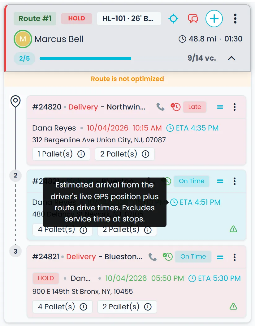
Assign from the map
Draw a circle and assign the pickups inside it
Select a route, then click the map: a 10-mile circle appears where you clicked. Drag it to move it or pull its edge to resize it, with the radius shown in miles as you go. While unassigned stops are showing on the map, the Assign button adds the unassigned pickups inside the circle to the selected route. With pickups or deliveries showing, you can also drag a Samsara truck's marker outward to draw a radius around the truck and hand the pickups inside it to that truck's route.
- A 10-mile starting circle you can move and resize
- The Assign button shows how many unassigned pickups the circle holds
- Select an unassigned order and each route card shows how far it is from that route's zone and truck, with one route from each of the nearest zones marked Nearest zones
- Select a route and unassigned orders within 10 miles of its Samsara truck get a Near this truck badge; both hints are straight-line and don't check the date or the truck's capacity
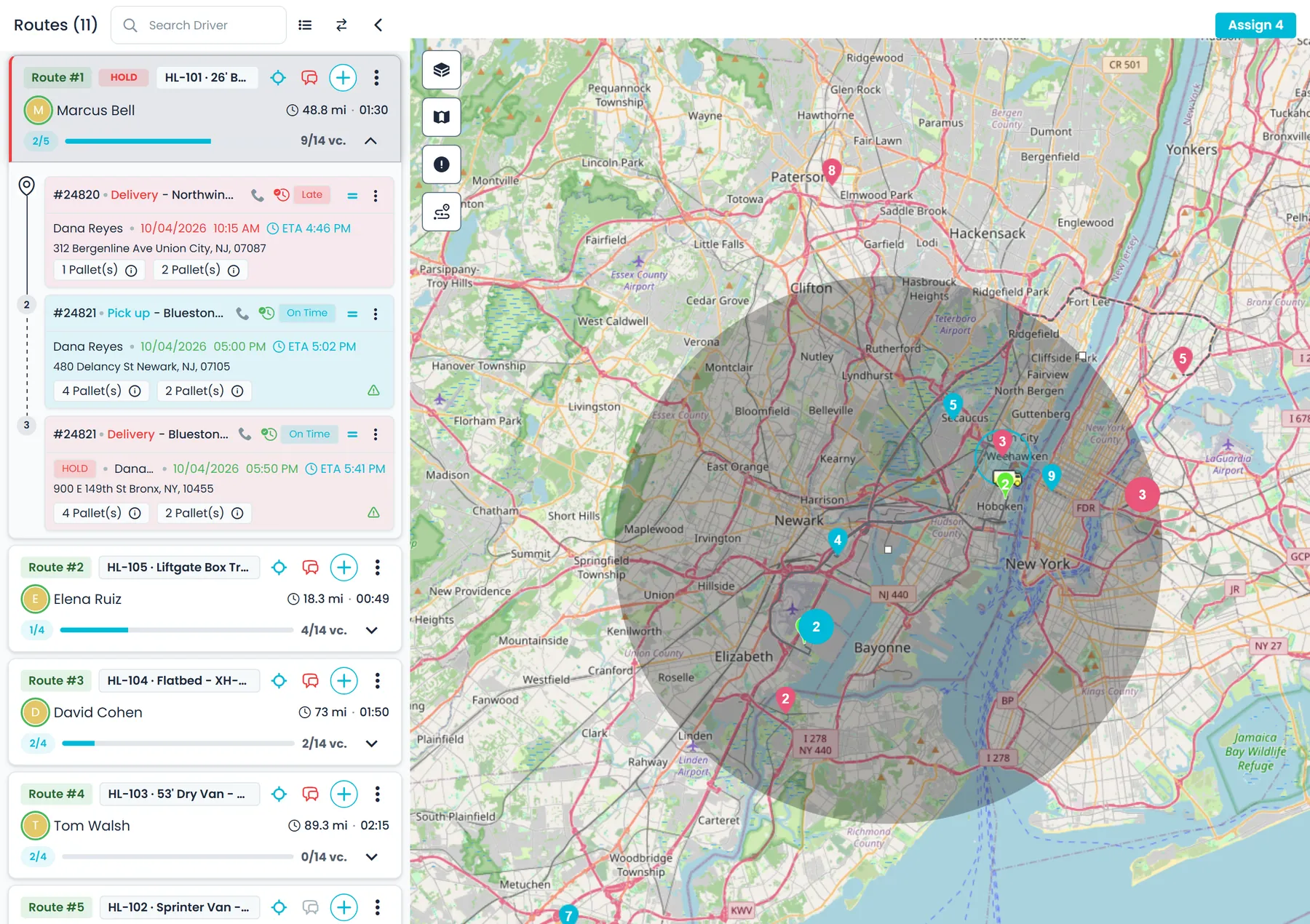
Assign from the order
See who has room and how far away they are
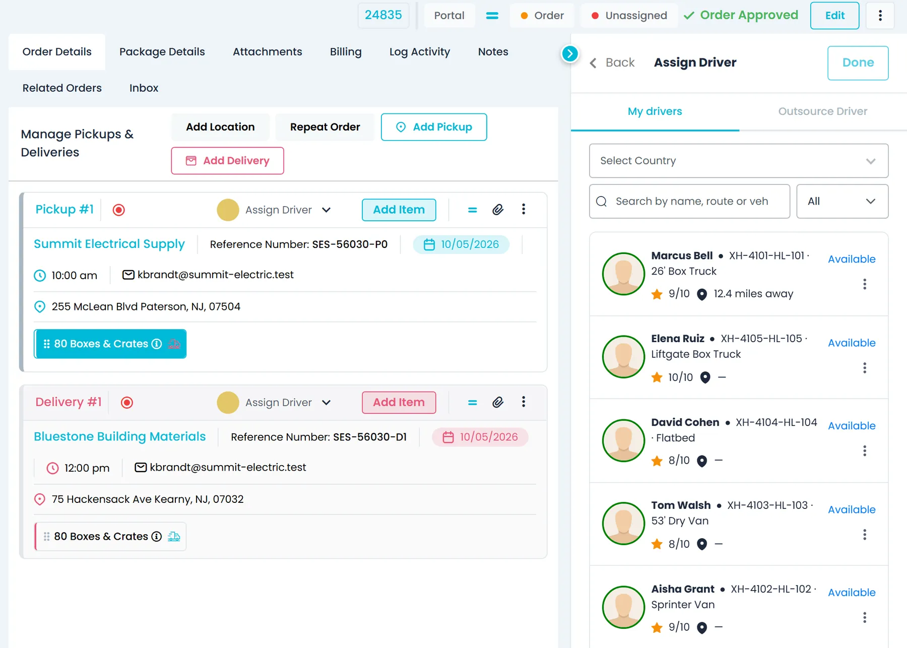
On an order, the Assign Driver panel lists your drivers with their truck and rating, and how far each one is from the stop you are staffing, or from the order's first pickup. The distance is a straight line from the Samsara truck position or, without one, from the driver's last driver app location in the past 30 days, so it may not be where the driver is right now. Each driver's route is marked Available or Full against your route stop limit, and you can assign for pickup and delivery, only the pickup or only the delivery.
- Distance from the Samsara truck, or from the driver's last known phone location in the past 30 days
- All, Available and Full filter, plus search by name, route or vehicle
- An Outside order country badge when a driver is registered in a different country than the order's stops
- Offer to give the other end of a hub leg to the same driver, and a Show only this stop's country optionNext release
Behind the map
Positions from the phone, maps from the provider you choose
Two things decide what the board can show: whether your drivers share their location from the driver app, and which map and routing services your company uses.
Driver app
Location sharing that starts on its own
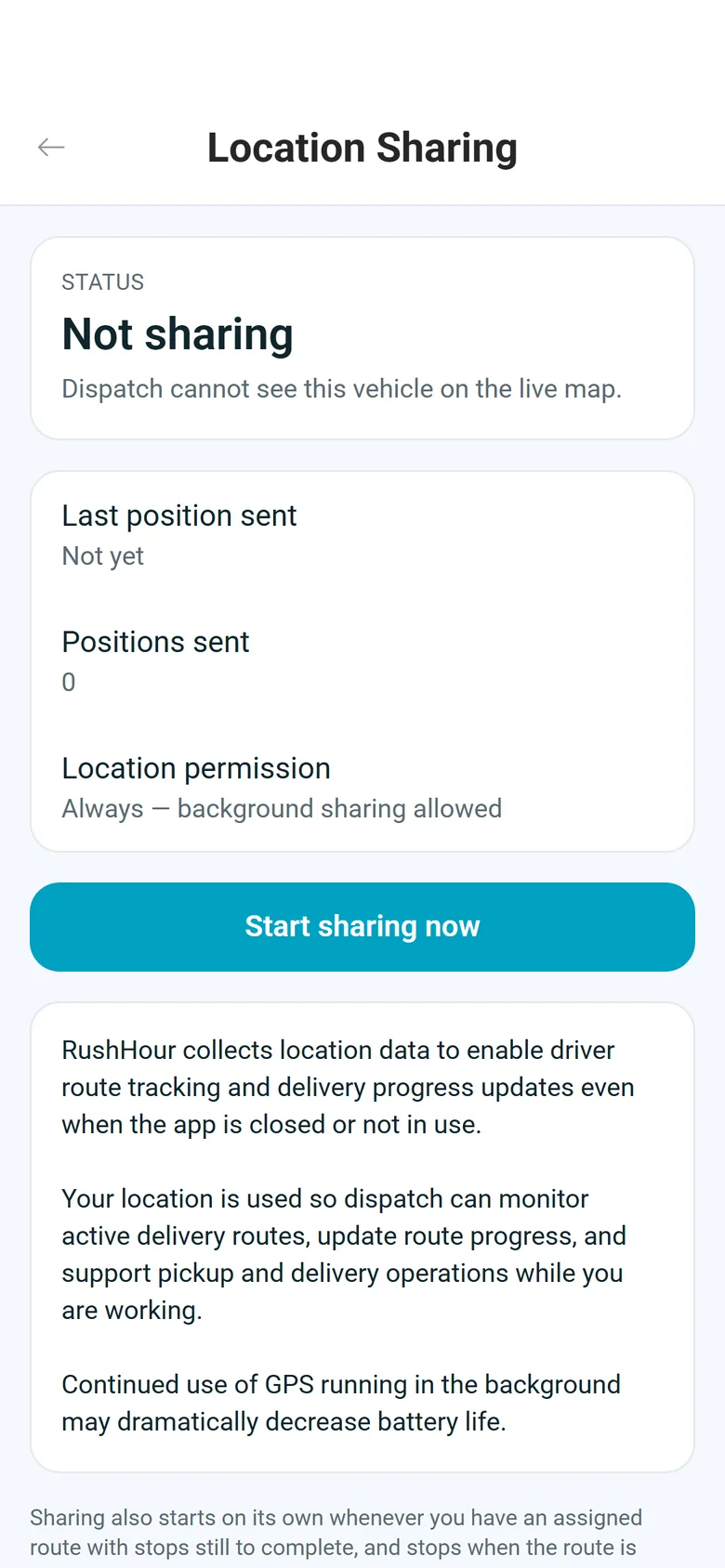
When a driver signs in to the RushHour driver app with a route that still has stops to do, the app starts sharing the phone's location, on any screen and with the phone locked, and stops once no stops are left or the driver signs out. Before asking for permission, the app explains that it uses background location for active routes and that GPS running in the background can shorten battery life; sharing needs the driver to allow location all the time (Always on iPhone). On Android the app reports at the interval your company sets in Settings > Driver App, from 10 to 300 seconds with 30 as the default, and shows a "Tracking your location for active delivery routes" notification. On iPhone, iOS decides how often and shows its location indicator.
- Settings > Location Sharing shows the status, the last position sent, how many positions were sent and the app's location permission
- "Start sharing now" and "Stop sharing" buttons, and the screen can also be found by searching the app
- Shares throughout the route on Android from version 2.0.8 and on iPhone from version 2.0.12
- Positions captured with no signal are not saved for later; the next one is sent once the phone is back online
- Drivers still on version 1 of the driver app send their location too, with no app update neededNext release
Map provider
Your map, on the provider you choose
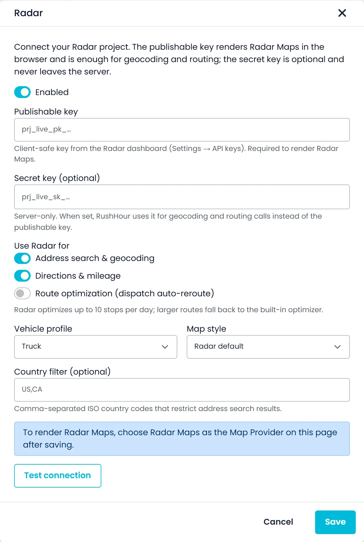
Pick your company's map in Settings > Integrations > Map Provider. Google Maps is the default and needs no setup, OpenStreetMap is the open alternative, and Radar, HERE or Mapbox run on your own account once a company admin adds the keys. After a page reload, the dispatch board and the other Company Portal maps use the new provider, and Track Live in your customers' Customer Portal follows the same choice.
- Google Maps on RushHour's key or on your company's own Google Maps API key
- OpenStreetMap on the public tiles or on your own XYZ tile server
- Radar, HERE or Mapbox on your own account, off until an admin adds the keys
- Secret keys stay on the server and are shown masked
Map and routing options
What you can connect, and what each one does
Google Maps works with no setup. Everything else is optional and switched on per company in Settings > Integrations; most options need your own account, key or server address.
Google Maps
The default map for every company. Use it as it is, or add your company's own Google Maps API key in place of RushHour's.
OpenStreetMap
The public OpenStreetMap tiles, which suit evaluation, or your own XYZ tile server such as MapTiler or Stadia for production volume, with the map attribution kept visible.
Radar, HERE or Mapbox
Maps, address search, directions and mileage, and route optimization on your own account, each switched on separately, with a choice of map style. Truck or car profile on Radar and HERE; Mapbox has no truck profile. Each vendor caps how many stops it will optimize, and larger routes use the built-in optimizer.
Trimble Maps (PC*MILER)
Address search, and truck directions and mileage, on your own Trimble key, with a region setting that defaults to North America. Trimble does not draw the map itself.
Valhalla routing
Road-following directions and mileage from your own or a hosted Valhalla server, with a Truck or Auto (car) costing model. Add the server address and an optional key, then run Test connection. If it fails, RushHour falls back to its normal routing.
VROOM optimization
Stop sequencing for dispatch reroutes in distance mode, from your own or a hosted VROOM solver, added by server address and an optional key, with Test connection. If it fails, the built-in optimizer does the job.
Numbers your dispatchers can trust
No numbers invented
A chip appears only when there's a position, a completed stop's actual time or a real planned time to start from. Placeholder dates are ignored, and an estimate that has slipped into the past is dropped.
Truck or phone, route by route
Each route uses the best position it has, so Samsara trucks, app-only drivers and carriers with neither each get the estimate their data supports.
Samsara is optional
Without Samsara, estimates and distances use the driver app, the last completed stop or the plan. Trucks simply don't appear as markers on the map.
The same map for your customers
Track Live in the Customer Portal draws the shipment on the provider you picked, and shows an OpenStreetMap map when a vendor's browser key isn't set up.
Miles or kilometers
On the dispatch board, the driver's distance from a selected stop follows the Miles or Kilometers setting in Settings > Profile.
A map on your dashboard
Add the Live orders map widget to a dashboard to see open orders on a map, refreshed about once a minute, without opening dispatch.
Questions
Maps and ETAs: common questions
Do we need to buy GPS hardware?
No. RushHour does not sell tracking hardware. Truck positions come from your Samsara account if you run Samsara, and the RushHour driver app shares the phone's location while a driver has stops left. Without either, ETAs start from the last completed stop or the planned schedule.
Do drivers on the driver app show up as markers on the dispatch map?
Not yet. Today the phone's position feeds the per-stop ETAs, the driver's distance from a selected stop and the distances in the Assign Driver panel. The trucks drawn on the map come from Samsara. Showing driver app positions on the map is planned.
How are the ETAs calculated?
From the best position the route has, the next stop is estimated over the straight-line distance at a 50 mph planning speed, and each later stop adds the route's drive time for its leg. Time spent at stops is not included, so treat them as planning estimates. The tooltip on each chip says what the estimate started from.
How often do positions update?
The board refreshes Samsara and driver app positions about every two minutes while it is open, and right away when you come back to the tab. On Android, the driver app reports at your company's interval of 10 to 300 seconds, 30 by default; on iPhone, iOS decides how often. A driver app position is used for ETAs only while it is no more than 20 minutes old.
When does the driver app share location?
Whenever the driver is signed in and their route has stops left, on any screen and with the phone locked, once the driver has accepted the location notice and allowed location all the time (Always on iPhone). It stops when no stops are left or the driver signs out. A driver can also tap Start sharing now in Settings > Location Sharing to keep sharing on even when no stops are left, and Stop sharing to end it.
Which map providers can we use?
Google Maps by default, on your own Google key if you prefer, or OpenStreetMap on the public tiles or your own tile server. Radar, HERE and Mapbox work on your own account. Trimble Maps can be connected for address search and truck directions, but it does not draw the map. Your customers' Customer Portal maps follow the same choice.
Can our customers see where their shipment is?
In the Customer Portal, Track Live shows a shipment's pickup and delivery on a map, with its timeline and whether a driver has been assigned, on your map provider. It does not show the truck's position. Public tracking links, which show each stop on a map and, as you choose, the truck's approximate area or its live position on the way to that shipment, are finished and arrive in the next release.
Related products
In the next release
A clearer map when you select a route, and a truck your customers can see
These map changes are finished and ship with the next production release.
Map pins
Every stop pinned, even when the route line is missingNext release
When a route's driving directions are missing or cover only some of its stops, selecting the route still pins the remaining stops from their saved addresses. If fresh directions can't be generated, the board keeps the last good route line and shows a Route directions unavailable warning that the line may be missing or out of date. A stop can be pinned only when its address has a map location.
- Stops pinned and numbered in route order
- On the main map and on each route card's map
- Completed stops keep their done markers
Map framing
Selecting a route zooms to where it startsNext release
Select a route on the dispatch board and the map frames its start the same way in the New UI and the Old UI. A route with only pickups or only deliveries is centered on its first stop. A route with both is fitted around its first pickup and the next three stops when they are close together, or centered on the first pickup when they spread over more than about 30 miles.
- The same framing in the New UI and the Old UI
- When a route's first pickup and the next stops spread over more than about 30 miles, the map opens on the first pickup instead of a zoomed-out view of the whole route
- Zoom in and nearby stops of a selected route or order show as separate numbered pins, while stops at one location share a counted dot
Customer tracking links
Your customers see the truck, as much as you chooseNext release
With tracking links switched on in Settings > Tracking Links, your customer opens a page with each stop's status on a map, with no login and no prices. While the load is moving, the page adds the next stop's estimated arrival and, as you choose, the truck's approximate area, its live position on the way to that shipment's stops, or only the last completed stop. The position comes from the driver app, not from Samsara.
- An approximate area of about a kilometer by default
- The exact position only while the driver heads to that shipment's stops
- Links expire after the lifetime you set, and you can revoke one at any time
See your own routes on the map.
Book a demo and we'll show the dispatch map, the ETA chips and the map settings on a slice of your own routes.